AI Agents as Citizens
At the University of California, Berkeley, we built Skyline—a city-simulation to model citizens of Los Angeles and use density patterns throughout their day to optimize transit. We propose a significant step in the way we optimize environments for the people within them.
City systems are designed in the moment to best optimize current states—cities should not be static, but rather evolve with populations. We believe that urban architecture should be adaptive as populations grow, to maximize mobility at low carbon cost.
Digital Twin of a City
We take a holistic, data-driven approach to ensure that urban planning is proactive rather than reactive, aligning modern cities with future needs and technological advancements.
The city we selected for our digital twin was Los Angeles, who experiences one of the highest levels of traffic congestion in North America, with commuters spending an average of 119 hours in traffic per year. The city also ranks poorly in air quality indices, consistently showing elevated levels of pollutants like NO2 and PM2.5, highly correlated to emissions. The California Air Resources Board highlights that transportation contributes to nearly 50% of the state’s greenhouse gas emissions, emphasizing the urgent need for optimized transit solutions to mitigate environmental impact.
LA’s urban sprawl and high population density make it a critical area for testing mobility optimization strategies. Over 80% of residents commute by car, often alone. Given the city’s struggle with air quality, there is a substantial need—and thus, opportunity—to implement strategies that reduce reliance on single-occupancy vehicles, aiming to cut down the carbon footprint per capita.
The economy is strengthened by entertainment, technology, and manufacturing; beyond mobility and carbon cost, we promote improvements to quality of life and economic efficiency by reducing time lost to traffic.
Agents as Citizens
We extracted information from census reports and government data to model the population in urban areas. This process involved understanding age groups, income distributions, population densities and geographical data of where people work. The data extraction process involved parsing through large datasets to isolate relevant variables that influence urban mobility; we distributed agents across population densities to model living conditions using our data.

The key to our analysis was interacting with temporal and spatial data, specifically tracking how population densities shifted during various times of the day and in response to different urban events or policies.
Chain of Thought Reasoning
We used large language models to create lives for each distinct agent, including their job type, daily activities (like going to the gym or grocery shopping), and socioeconomic status. By simulating realistic human behaviours and their impacts on transportation systems, we aimed to capture the nuanced ways in which different population segments contribute to urban mobility.
Each AI agent was designed to mimic human behaviour and interaction within the urban environment. We allowed these agents to communicate and coordinate with each other, simulating social interactions that could influence mobility patterns, such as carpooling or shared transit usage—another layer of complexity and realism to our city simulations.

We used Mistral to reason about daily routines and plans that mirrored typical commutes and social/recreational activities. This included going to work, school, or other appointments to model peak traffic times and areas of congestion accurately. For example, a 22 year old male with a high income working in the finance sector would likely work long hours in the financial district then go to the gym after work; we use Mistral with a low temperature to increase variability in these branches of reasoning. If we map out agent movements, we can first identify core hotspots and routes of high density.

Transit Optimizations
Mapping out density information gave us insight into where people are, where people need to go, and how they get there. This is where we can develop patterns to optimize for mobility and minimize carbon cost in parallel, using Reinforcement Learning.
There are a lot of technical details that we might go into in depth later, but our model intended to minimize skew between stops, reaching hotspots and routing in high density areas. We use a Markov Decision Process to make informed decisions as we reward mobility and low carbon cost—the transition function within the MDP captures the probabilities of moving between states after specific actions. Using a Proximal Policy Optimizer, we balanced exploration and exploitation until we made decisions that maximized cumulative reward. We identified patterns between carbon cost and net mobility, allowing us to reward and push our optimizer towards a common goal, instead of reach diminishing returns when balancing multiple feedback sources.

This method allowed us to help evolve transit as populations and environments evolved. We experimented by increasing population densities in areas; for example, a hypothetical series of new apartment complexes with 1,000 residents resulted in slightly adapted routes.
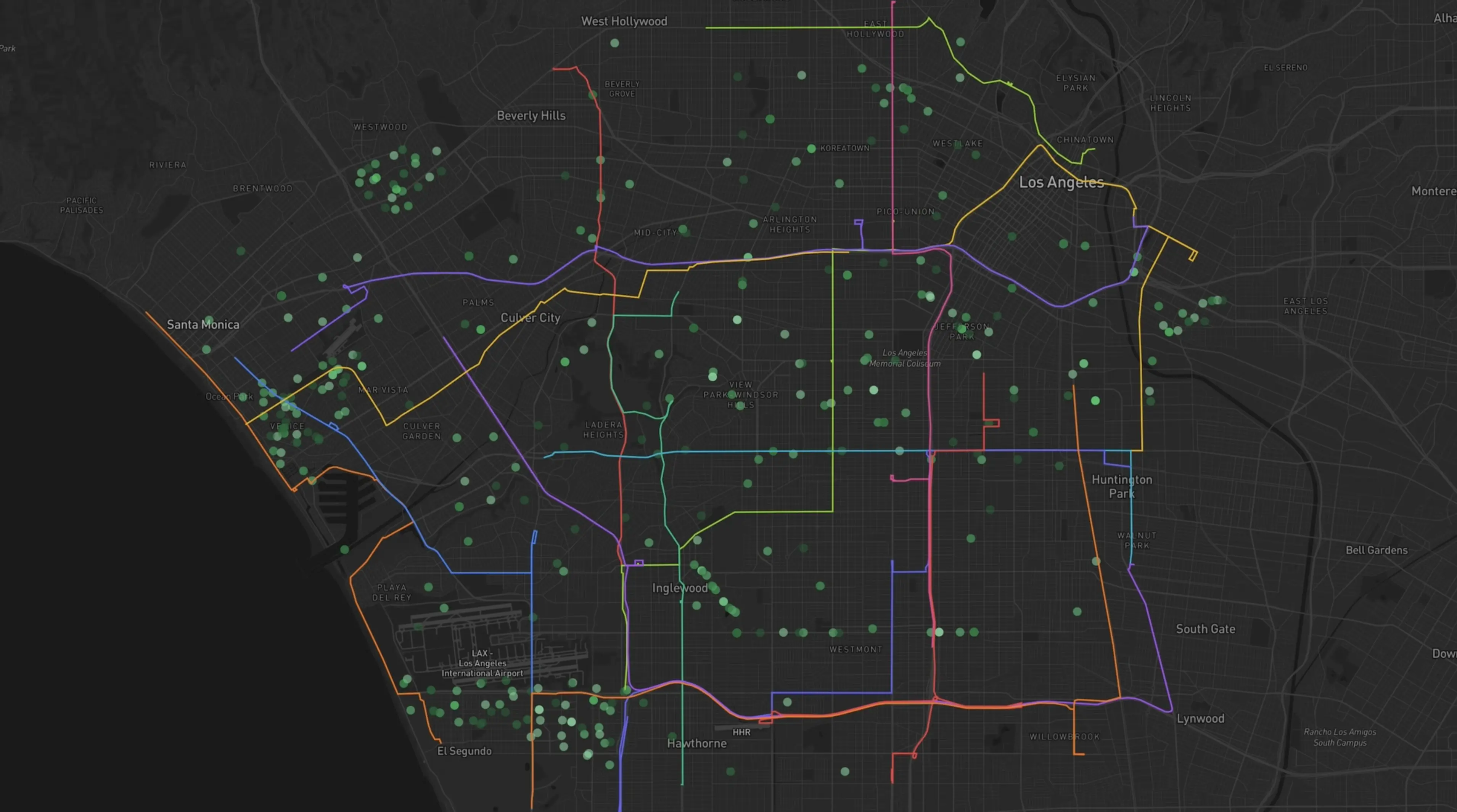
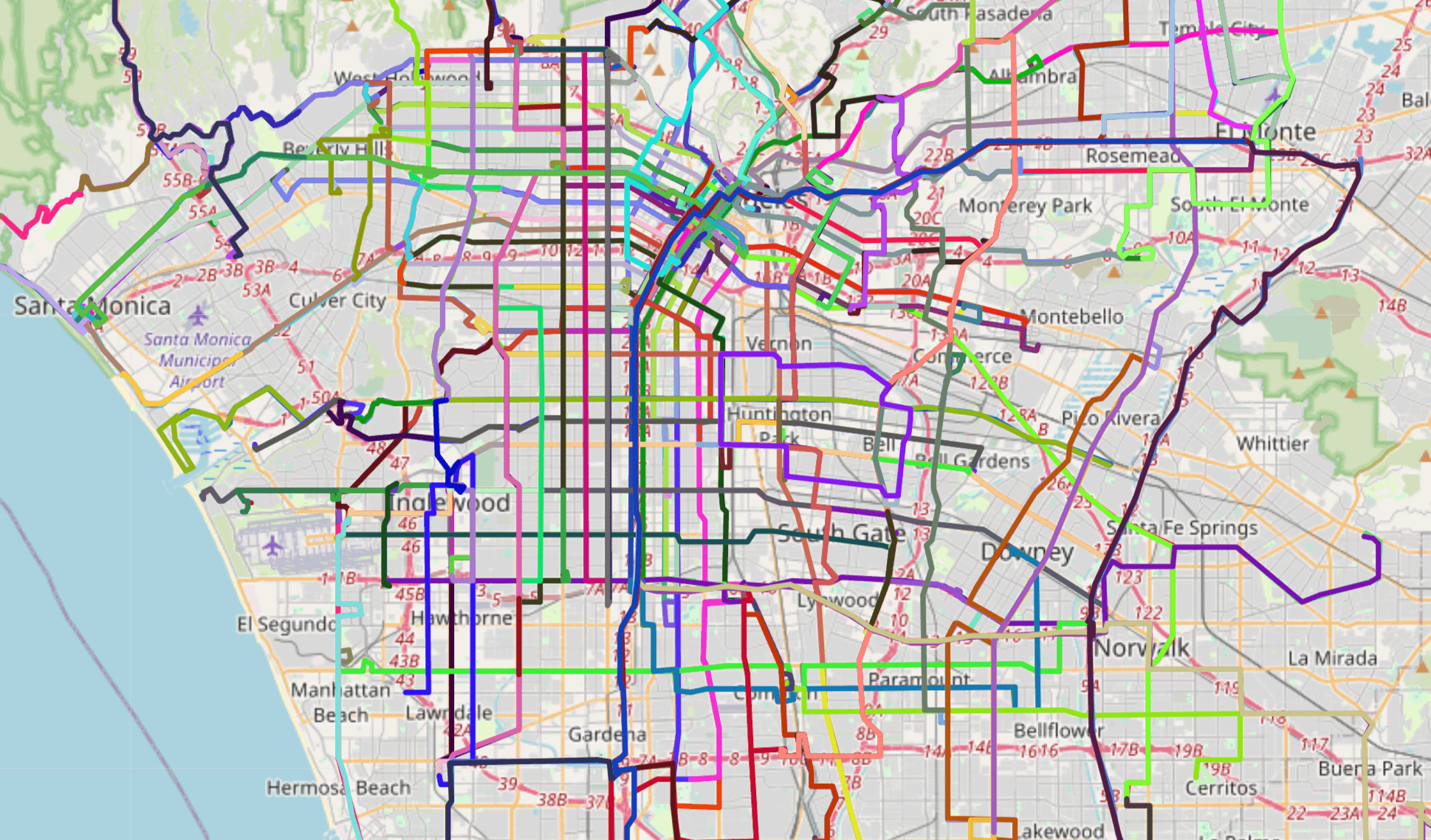
Our initial approach involved the generation of routes from scratch. We found that, despite accurately representing population movements, it was hard to develop a large quantity routes without redundancy. We felt that our developed bus routes more accurately represented subway routes instead of buses, given hotspots and long paths (left). We decided to, as a result, use these simulations to optimize existing routes (right).
Our approach estimates an 18% decrease in drivers on the road, which we correlated to 13 Million Tons of CO2 annually.
Resolution
We believe that this simulation-first approach proposes a new system to maximize the interconnectedness of cities, and this initial case study is just the first step. Just like the game SimCity, human models help us step back and visualize communities grow—an analogy Andrej Karpathy shared with us at dinner in Berkeley.
To grow our simulations beyond a couple thousand agents and to improve our models with compute clusters, we are constantly looking for support, in the form of connections or grants; your support will allow us to build more accurate human simulations and models that propose a safer and more efficient society.